FURUNO SC-50 Satellite Compass – Complete Technical Guide, Operation, Maintenance & Troubleshooting
Maker : FURUNO
Model :
FURUNO SC-50 Satellite Compass
Complete Marine Technical Guide for Accurate Heading and Position Information
Product Identification
| Item | Details |
|---|---|
| Manufacturer | FURUNO Electric Co., Ltd. |
| Country of Origin | Japan |
| Product Type | Satellite Compass |
| Model | SC-50 |
| Technology | GPS/GNSS Heading Determination |
| Marine Application | Heading, Position, ROT & Navigation Data |
| Installation | Bridge Display + Deck Antenna Unit |
| Interface | IEC 61162 / NMEA 0183 |
| Compliance | IMO, SOLAS, IEC Standards |
The FURUNO SC-50 Satellite Compass is an advanced marine heading sensor that uses multiple GPS satellites to provide highly accurate vessel heading, position, course, speed, and Rate of Turn (ROT) information without relying on traditional gyrocompass technology.
The SC-50 is widely used aboard merchant ships, offshore vessels, fishing vessels, dredgers, patrol vessels, and workboats where reliable heading information is required.
Product Introduction
Traditional magnetic compasses and gyrocompasses have been used for decades to determine vessel heading. However, satellite compass technology introduced a new level of accuracy and reliability.
The FURUNO SC-50 utilizes multiple satellite signals and dual-antenna processing technology to calculate:
- True Heading
- Position
- Course Over Ground (COG)
- Speed Over Ground (SOG)
- Rate of Turn (ROT)
- Time & Navigation Data
Unlike magnetic compasses, the SC-50 is unaffected by magnetic interference and unlike gyrocompasses, it requires no spinning gyros.
Main Product Image


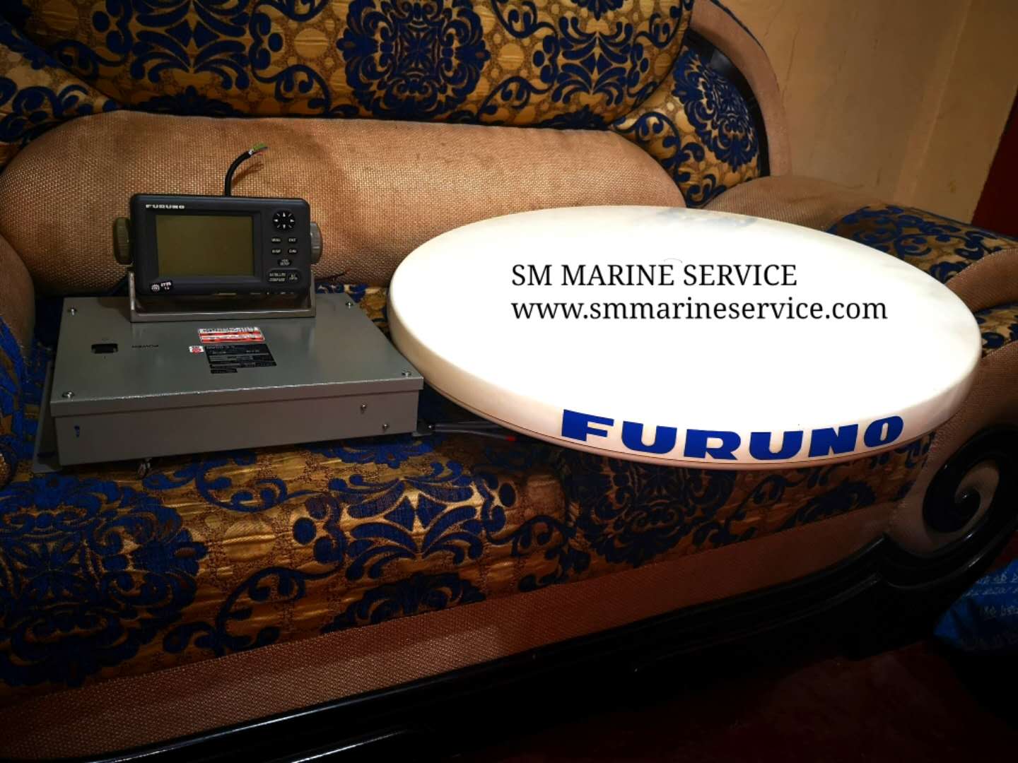
The image above shows a complete FURUNO SC-50 system including the display unit, processor unit, and satellite antenna assembly.
What Is a Satellite Compass?
A Satellite Compass is a navigation instrument that calculates vessel heading by comparing GPS/GNSS signals received simultaneously by multiple antennas.
Instead of detecting magnetic north or using gyro technology, the SC-50 determines heading mathematically from satellite positioning data.
The system continuously provides:
True Heading
Accurate vessel heading relative to true north.
Position Information
Latitude and Longitude.
Course Over Ground (COG)
Actual direction of movement.
Speed Over Ground (SOG)
Actual vessel speed relative to Earth.
Rate of Turn (ROT)
Vessel turning information.
Satellite Compass Operating Principle


Main Features
Highly Accurate Heading Information
Provides heading accuracy typically better than conventional magnetic compasses.
No Gyroscope Required
Eliminates moving mechanical gyro components.
Instant Start-Up
Unlike gyrocompasses, no settling time is required.
True Heading Output
Provides heading relative to true north.
Integrated GPS Receiver
Combines heading and position information in a single system.
Rate of Turn Output
Provides ROT data for navigation systems.
Multi-System Integration
Supports:
- ECDIS
- Radar
- AIS
- Autopilot
- VDR
- Dynamic Positioning Systems
Low Maintenance
Few moving parts and high reliability.
Navigation Display Functions
Main Components
1. Satellite Antenna Unit
Installed externally with clear sky visibility.
Functions
- GPS Signal Reception
- Heading Calculation Support
- Position Determination
2. Processor Unit
Processes satellite signals and calculates heading.
Functions
- Heading Computation
- Position Calculation
- ROT Generation
- Data Distribution
3. Display Unit
Installed on the bridge.
Functions
- Heading Display
- Position Monitoring
- Alarm Monitoring
- Configuration Management
4. Communication Interface
Distributes navigation data throughout the vessel.
Supports
- ECDIS
- Radar
- AIS
- VDR
- Autopilot
5. Power Supply System
Provides stable operation for all modules.
Typical System Architecture


Marine Applications
The SC-50 is widely used aboard:
Container Ships
Provides heading information for ECDIS and radar.
Oil & Chemical Tankers
Supports safe navigation and maneuvering.
Bulk Carriers
Enhances navigation accuracy.
Offshore Support Vessels
Supports dynamic positioning systems.
Fishing Vessels
Provides reliable heading and position information.
Passenger Ships
Improves navigational safety.
Dredgers
Supports precision operations.
Common Problems & Troubleshooting
1. Heading Data Not Available
Possible Causes
- Satellite reception problem
- Antenna cable failure
- Processor malfunction
Corrective Actions
- Verify antenna condition
- Inspect antenna cabling
- Check processor diagnostics
2. Poor Heading Accuracy
Possible Causes
- Antenna obstruction
- Multipath interference
- Incorrect antenna installation
Solution
- Verify clear sky visibility
- Check antenna mounting
- Inspect installation alignment
3. GPS Position Lost
Causes
- Weak satellite signals
- Antenna failure
- Power supply issue
Solution
- Verify antenna operation
- Check cable integrity
- Inspect power supply
4. No Output to Radar or ECDIS
Causes
- Communication failure
- NMEA configuration error
Solution
- Verify interface settings
- Inspect communication cables
5. ROT Data Unstable
Causes
- Satellite signal interruption
- Processor issue
Solution
- Verify satellite tracking
- Review diagnostic information
Maintenance Tips
Proper maintenance ensures long-term performance.
Daily Checks
- Verify heading indication
- Confirm position accuracy
- Review alarms
Weekly Checks
- Inspect display operation
- Verify data outputs
- Review event logs
Monthly Checks
- Inspect antenna condition
- Check communication interfaces
- Verify heading performance
Annual Maintenance
Recommended:
- Antenna inspection
- Cable testing
- Output verification
- Complete functional testing
Antenna Care
Regularly inspect the antenna radome for:
- Cracks
- Corrosion
- Water ingress
- Physical damage
Why Ships Use Satellite Compasses
Modern vessels increasingly rely on satellite compasses because:
Instant Heading Availability
No lengthy gyro settling period.
No Moving Parts
Reduced maintenance requirements.
Accurate True Heading
Provides reliable navigation information.
Integrated Position Information
Heading and GPS data in one system.
Easy Installation
Compact antenna and processor design.
Excellent Reliability
Suitable for commercial marine operations.
Frequently Asked Questions (FAQ)
What does the SC-50 provide?
The SC-50 provides true heading, position, speed, course, and rate of turn information.
Is it a replacement for a gyrocompass?
On many vessels it serves as a heading sensor, although SOLAS requirements depend on vessel type and operational regulations.
Does it work while the vessel is stationary?
Yes. Unlike magnetic compasses, heading can be determined even when the vessel is not moving.
Can it connect to ECDIS and Radar?
Yes. The SC-50 is commonly connected to ECDIS, Radar, AIS, VDR, and Autopilot systems.
Is maintenance difficult?
No. The system has minimal moving parts and generally requires only routine inspections.
Short Product Description
The FURUNO SC-50 Satellite Compass is a professional marine heading and positioning system that uses advanced GPS/GNSS technology to provide highly accurate true heading, position, speed, course, and rate of turn information. Featuring rapid start-up, low maintenance, and seamless integration with ECDIS, Radar, AIS, Autopilot, and VDR systems, the SC-50 remains a trusted navigation solution for vessels worldwide.
SC – 50
Description : Furuno Satellite Compass SC – 50
Condition : Refurbished
SM MARINE SERVICE™
Marine Automation & Navigation Equipment Supplier
Available Condition:
• New Equipment • Used Equipment • Refurbished Equipment • Reconditioned Equipment
Stock Location:
• Bangladesh • China
Services:
• Worldwide Shipping • Technical Support • Spare Parts Supply • Marine Equipment Sourcing
Contact Information
SM MARINE SERVICE™
Samir Market, DT Road, Pahartali, beside CDA Market, Chattogram, Bangladesh
please email us
Email : sohelbhuiyan1213@gmail.com
Email : info@smmarineservice.com
Web : www.smmarineservice.com
Whatsapp :+8801818929292/+8801675626797