Transas Navi-Sailor 4000 (NS4000) ECDIS – Complete Technical Guide, Operation, Maintenance & Troubleshooting
Transas Navi-Sailor 4000 (NS4000) ECDIS
Complete Marine Technical Guide for Professional Electronic Navigation
Product Identification
| Item | Details |
|---|---|
| Manufacturer | Transas Marine Ltd. |
| Current Brand Owner | Wärtsilä Voyage |
| Country of Origin | Finland / Russia (Original Development) |
| Product Type | Electronic Chart Display and Information System (ECDIS) |
| Model | Navi-Sailor 4000 (NS4000) |
| Application | Electronic Navigation & Voyage Planning |
| Compliance | IMO MSC.232(82), IEC 61174, SOLAS |
| Chart Support | ENC, SENC, ARCS, Admiralty Raster Charts |
| Installation Location | Navigation Bridge |
The Transas Navi-Sailor 4000 (NS4000) is one of the most widely installed ECDIS systems in the maritime industry. Designed for commercial vessels, offshore vessels, tankers, and passenger ships, the NS4000 provides advanced electronic chart navigation, route planning, route monitoring, AIS integration, radar overlay, and navigational safety management.
Product Introduction
The maritime industry has gradually replaced traditional paper charts with Electronic Chart Display and Information Systems (ECDIS). Among the most successful systems developed for this transition is the Transas Navi-Sailor 4000 (NS4000).
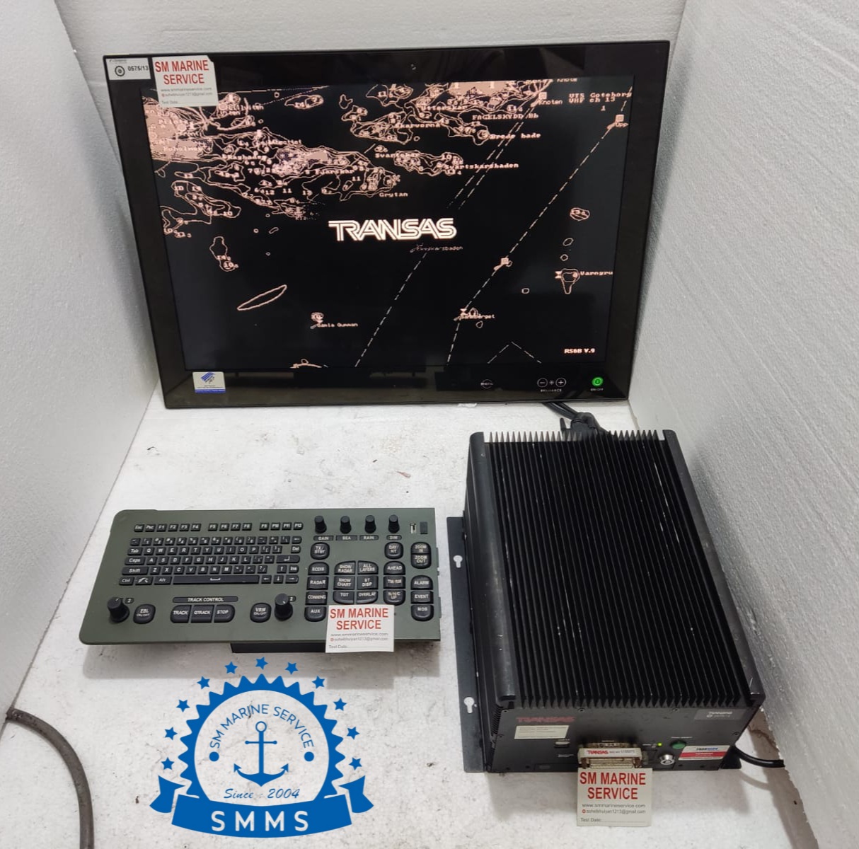
The system shown in the image includes:
- NS4000 Industrial Processor Unit
- Marine Display Monitor
- Dedicated Navigation Keyboard
- Radar/ECDIS Control Panel
- Integrated Navigation Software
The NS4000 became popular due to its reliability, user-friendly interface, and compatibility with numerous shipboard navigation sensors.
Main Product Image


The image above shows a complete Transas NS4000 ECDIS workstation with marine display, industrial processor, and dedicated navigation control keyboard.
What Is the Transas Navi-Sailor 4000?
The Navi-Sailor 4000 is an IMO-approved ECDIS system that integrates navigation charts and vessel sensor data into a single operational platform.
The system continuously receives information from:
- GPS / DGPS
- Gyro Compass
- Doppler Speed Log
- AIS
- Radar
- Echo Sounder
- Autopilot
- Voyage Data Recorder (VDR)
This information is displayed directly on electronic navigation charts, allowing navigators to monitor vessel position and voyage progress in real time.
Typical ECDIS Bridge Installation


Main Features
Electronic Navigational Charts (ENC)
Supports official ENC charts compliant with IHO standards.
Route Planning
Provides advanced voyage planning functions including:
- Waypoint Creation
- Safety Margins
- No-Go Areas
- Turning Circles
- Speed Planning
Route Monitoring
Monitors vessel movement and generates warnings if the vessel deviates from the approved route.
Radar Overlay
Allows radar targets and chart information to be displayed simultaneously.
AIS Integration
Displays AIS-equipped vessels directly on the chart display.
Automatic Safety Alarms
Generates alerts for:
- Cross Track Error
- Safety Depth Violation
- Safety Contour Breach
- Route Deviation
- AIS CPA/TCPA Warnings
- Sensor Failures
Chart Management
Supports:
- ENC Updates
- Chart Licensing
- Automatic Corrections
- Voyage Archive Management
ECDIS Control Console


Main Components
1. ECDIS Processing Unit
Industrial navigation computer responsible for:
- Chart Rendering
- Data Processing
- Route Management
- Alarm Generation
2. Marine Display Unit
Provides chart visualization and navigation information.
Functions
- Chart Display
- AIS Monitoring
- Route Tracking
- Alarm Management
3. Dedicated Navigation Keyboard
Designed specifically for marine navigation operations.
Functions
- Route Editing
- Chart Control
- Alarm Acknowledgement
- Menu Navigation
4. Electronic Chart Database
Stores:
- ENC Charts
- Route Plans
- Voyage Archives
- User Settings
5. Communication Interfaces
Connects with:
- GPS
- AIS
- Radar
- Gyro Compass
- Speed Log
- VDR
System Architecture


Marine Applications
The NS4000 is widely used aboard:
Container Ships
Supports long ocean passages and complex route planning.
Oil & Chemical Tankers
Provides enhanced navigation safety in environmentally sensitive areas.
Bulk Carriers
Improves route monitoring and voyage efficiency.
LNG & LPG Carriers
Supports high-safety navigation operations.
Offshore Vessels
Provides reliable route management for offshore missions.
Passenger Ships
Enhances navigation safety in congested waterways.
Common Problems & Troubleshooting
1. GPS Position Lost
Symptoms
- Position unavailable
- Vessel symbol disappears
Causes
- GPS receiver fault
- Antenna problem
- Interface failure
Solution
- Check GPS signal
- Inspect antenna
- Verify communication settings
2. ENC Chart License Error
Symptoms
- Charts unavailable
- License warnings
Causes
- Expired license
- Corrupted permit files
Solution
- Update chart permits
- Verify chart subscription
3. Radar Overlay Not Working
Causes
- Radar interface failure
- Network communication issue
Solution
- Verify radar connection
- Check communication settings
4. AIS Targets Missing
Causes
- AIS communication loss
- Serial port misconfiguration
Solution
- Check AIS data input
- Verify communication settings
5. Continuous Safety Alarms
Causes
- Incorrect safety contour settings
- Route planning errors
- Sensor discrepancies
Solution
- Review alarm details
- Verify safety parameters
- Confirm sensor accuracy
Maintenance Tips
Daily Checks
- Verify GPS position
- Check chart display
- Confirm AIS targets
- Review alarms
Weekly Checks
- Backup route plans
- Verify communication interfaces
- Review event logs
Monthly Checks
- Test alarms
- Verify chart database integrity
- Inspect hardware condition
ENC Chart Updates
Regular chart updates are essential for compliance and navigation safety.
Always:
- Install latest ENC updates
- Verify chart permits
- Review correction reports
Hardware Maintenance
- Clean monitor screens
- Inspect cooling systems
- Check keyboard operation
- Verify cable connections
Why Ships Still Use NS4000
Although newer ECDIS platforms exist, thousands of vessels continue operating NS4000 systems because:
Proven Reliability
Widely tested on commercial fleets worldwide.
User-Friendly Interface
Easy for bridge officers to operate.
Full IMO Compliance
Meets international ECDIS requirements.
Excellent Sensor Integration
Supports legacy and modern navigation equipment.
Extensive Fleet Adoption
One of the most common ECDIS systems ever installed.
Frequently Asked Questions (FAQ)
What is the purpose of the NS4000?
To provide electronic chart navigation, route planning, and route monitoring for commercial vessels.
Can NS4000 replace paper charts?
Yes, when used with approved ENC charts and in compliance with IMO regulations.
Does it support radar overlay?
Yes. Radar overlay is one of the core functions of the NS4000 platform.
Can AIS targets be displayed?
Yes. AIS information is integrated directly onto electronic charts.
Is NS4000 still supported?
Many vessels continue operating NS4000 systems, although support and upgrades are now generally handled through Wärtsilä Voyage services.
Short Product Description
The Transas Navi-Sailor 4000 (NS4000) ECDIS is a professional electronic chart navigation system designed for commercial marine vessels. Featuring ENC chart support, advanced route planning, AIS integration, radar overlay, safety alarms, and multi-sensor connectivity, the NS4000 remains one of the most recognized ECDIS platforms in the maritime industry.
SM MARINE SERVICE™
Marine Automation & Navigation Equipment Supplier
Available Condition:
• New Equipment • Used Equipment • Refurbished Equipment • Reconditioned Equipment
Stock Location:
• Bangladesh • China
Services:
• Worldwide Shipping • Technical Support • Spare Parts Supply • Marine Equipment Sourcing
Contact Information
SM MARINE SERVICE™
Samir Market, DT Road, Pahartali, beside CDA Market, Chattogram, Bangladesh
Mobile / WhatsApp / Viber: +88 01818 929292
Email: info@smmarineservice.com
Website: www.smmarineservice.com