FURUNO FELCOM 18 Inmarsat-C Mobile Earth Station – Complete Marine Technical Guide
FURUNO FELCOM 18 Inmarsat-C Mobile Earth Station – Complete Marine Technical Guide
Product Identification
Manufacturer: Furuno Electric Co., Ltd.
Country of Origin: Japan
Product Type: Inmarsat-C Mobile Earth Station (MES)
Model: FELCOM 18
Marine Application:
- GMDSS Communication
- Inmarsat-C Messaging
- LRIT Reporting
- SSAS (Ship Security Alert System)
- EGC SafetyNET Reception
- Distress Alert Communication
- Ship-to-Shore Data Communication
The FURUNO FELCOM 18 is a globally recognized Inmarsat-C terminal designed for merchant ships, tankers, bulk carriers, offshore vessels, fishing vessels, and government vessels requiring reliable satellite communication and GMDSS compliance.
Product Introduction
The FURUNO FELCOM 18 is an advanced Inmarsat-C Mobile Earth Station that enables worldwide satellite communication through the Inmarsat network.
Unlike conventional radio systems, the FELCOM 18 provides reliable communication regardless of distance from shore. The system supports distress messaging, email transmission, telex communication, EGC SafetyNET services, polling, data reporting, LRIT reporting, and vessel security functions.
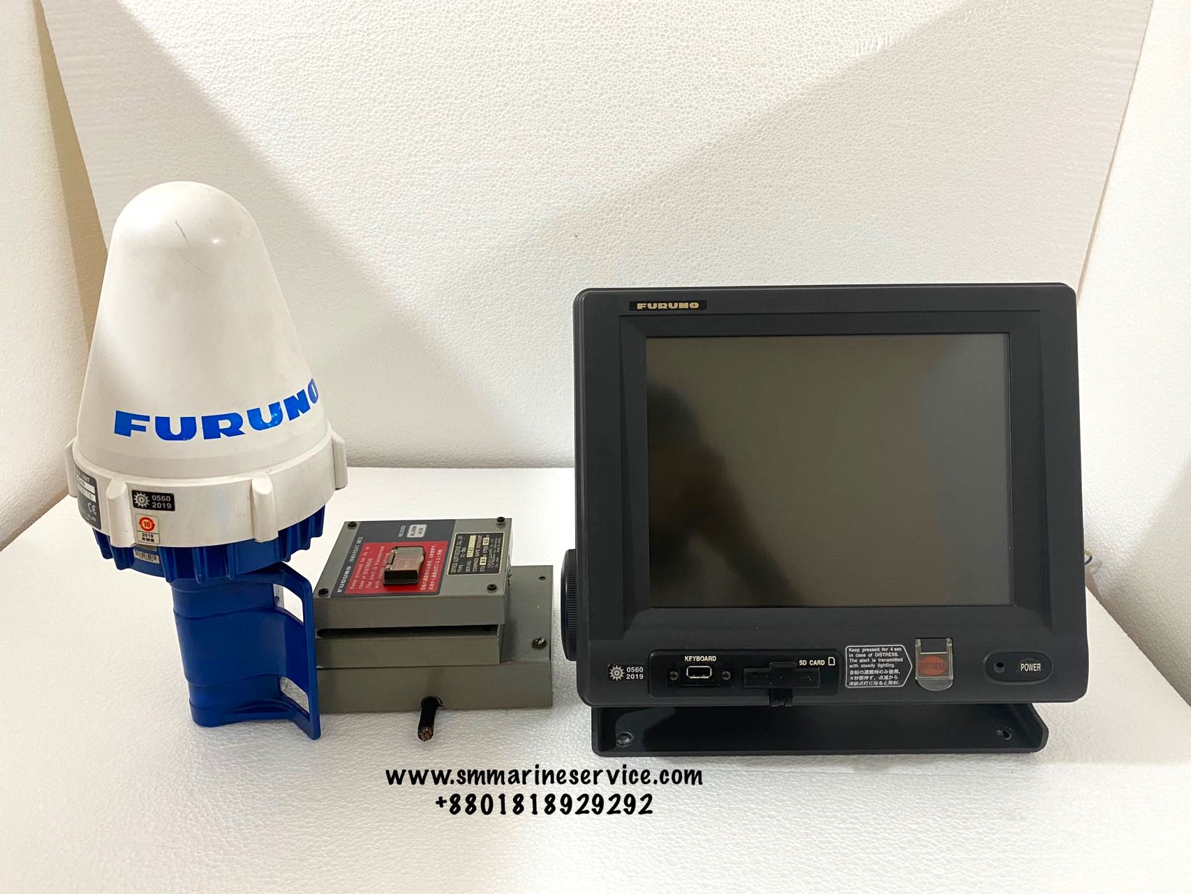
Actual FURUNO FELCOM 18 System


What Is This Equipment?
The FELCOM 18 is an Inmarsat-C communication terminal that operates through geostationary satellites.
It provides:
- Worldwide satellite messaging
- Distress alert transmission
- Maritime Safety Information (MSI)
- LRIT vessel reporting
- Ship Security Alert System (SSAS)
- Email communication
- Data reporting and polling
The system is fully compatible with GMDSS requirements and can be configured to meet international maritime safety regulations.
Main Features
Global Satellite Coverage
Provides communication through the Inmarsat-C network.
Distress Alert Function
Dedicated distress alert capability for emergency situations.
EGC SafetyNET Reception
Receives navigational warnings, weather forecasts, and safety information.
LRIT Compatible
Supports Long Range Identification and Tracking requirements.
SSAS Capability
Supports Ship Security Alert System operation.
Email & Data Communication
Allows transmission and reception of email and digital messages.
SD Card Support
Used for data recording, backup, and software updates.
Optional Internal GPS
Supports automatic position reporting.
Typical FELCOM 18 Components


Main Components
Antenna Unit (IC-118)
Provides satellite communication link with Inmarsat satellites.
Terminal Unit (IC-218)
Main operating workstation with display and keyboard functions.
Junction Box (IC-318)
Interconnection point for system wiring.
Distress Alert Unit (IC-305)
Used to activate emergency distress messages.
Alarm Unit (IC-306)
Provides audible alarm indications.
Printer (Optional)
Prints received messages and safety information.
GPS Board Kit (Optional)
Provides automatic vessel position updates.
Technical Specifications
Communication Services
- Inmarsat-C Messaging
- Telex
- SafetyNET
- FleetNET
- Polling
- Data Reporting
Display
10.4-inch color LCD display.
Recording Media
SD Memory Card.
Satellite Network
Inmarsat-C.
Position Reporting
GPS compatible.
Compliance
- GMDSS
- LRIT
- SSAS
Power Supply
12/24 VDC (depending on configuration).
Shipboard Applications
Cargo Vessels
Primary GMDSS satellite communication.
Tankers
Emergency and routine communication.
Offshore Vessels
Remote communication support.
Fishing Vessels
Long-range operational communication.
Government Vessels
Security and tracking operations.
Research Ships
Global scientific communication support.
Typical Onboard Installation

Common Problems & Troubleshooting
Login Failure
Possible Causes
- Satellite synchronization issue
- Incorrect ocean region selection
- Communication interruption
Solution
- Verify satellite lock
- Confirm correct NCS selection
- Restart terminal and login again
Distress Alert Not Available
Possible Causes
- System configuration issue
- GPS input failure
- Terminal fault
Solution
- Verify distress unit operation
- Check GPS position data
- Review system status menu
No EGC Messages Received
Possible Causes
- Wrong ocean region
- Poor antenna visibility
- Configuration issue
Solution
- Verify EGC setup
- Check antenna orientation
- Confirm SafetyNET settings
GPS Position Missing
Possible Causes
- GPS board fault
- External GPS communication failure
Solution
- Verify GPS connection
- Check NMEA communication
Printer Failure
Possible Causes
- Paper jam
- Printer offline
- Communication error
Solution
- Replace paper roll
- Verify printer connection
- Restart printer system
Maintenance Recommendations
Daily
- Verify satellite synchronization.
- Check distress alert status.
Weekly
- Review received SafetyNET messages.
- Inspect antenna condition.
Monthly
- Test communication functions.
- Verify LRIT reporting.
Quarterly
- Check all cable connections.
- Verify alarm unit operation.
Annual
- GMDSS survey.
- Satellite communication verification.
- Software update if required.
Why Ships Still Use Inmarsat-C
Despite modern broadband satellite systems, Inmarsat-C remains mandatory and widely used because:
- Reliable distress communication
- Low operating cost
- Global maritime acceptance
- GMDSS compliance
- LRIT reporting capability
- Proven long-term reliability
For many vessels, Inmarsat-C remains one of the most critical emergency communication systems onboard.
Frequently Asked Questions (FAQ)
What is FELCOM 18 used for?
It is used for GMDSS communication, distress alerting, SafetyNET reception, email, LRIT, and SSAS operation.
Is FELCOM 18 GMDSS approved?
Yes, it was specifically designed for GMDSS applications.
Can FELCOM 18 send email?
Yes. It supports e-mail, telex, polling, and data communication.
Does FELCOM 18 support LRIT?
Yes, LRIT functionality is supported.
Does FELCOM 18 support SSAS?
Yes, optional SSAS alert units can be integrated.
Short Product Description
The FURUNO FELCOM 18 is a professional Inmarsat-C Mobile Earth Station designed for global maritime communication, GMDSS compliance, LRIT reporting, and vessel security applications. Featuring satellite messaging, SafetyNET reception, distress alerting, and optional SSAS integration, the FELCOM 18 remains one of the most trusted Inmarsat-C systems installed aboard commercial vessels worldwide.
SM MARINE SERVICE™
Marine Automation & Navigation Equipment Supplier
Available Condition:
- New Equipment
- Used Equipment
- Refurbished Equipment
- Reconditioned Equipment
Stock Location:
- Bangladesh
- China
Services:
- Worldwide Shipping
- Technical Support
- Spare Parts Supply
- Marine Equipment Sourcing
Contact Information
SM MARINE SERVICE™
Samir Market, DT Road, Pahartali, beside CDA Market, Chattogram, Bangladesh
Mobile / WhatsApp / Viber: +88 01818 929292
Email: info@smmarineservice.com
Website: www.smmarineservice.com
SM MARINE SERVICE™ supplies FURUNO Inmarsat-C Systems, AIS, GPS, Radar, ECDIS, Gyro Compass, Navtex Receivers, VDR Systems, Satellite Communication Equipment, Marine Automation Equipment, and Navigation Spare Parts worldwide.
User Manual & Technical Resources
Download Information: