FURUNO GP-170 GPS Navigator – Complete Marine GPS Navigation System Guide, Features, Applications, Maintenance & Troubleshooting
FURUNO GP-170 GPS Navigator – Complete Technical Guide for Marine Navigation Professionals
Product Identification
Manufacturer: Furuno Electric Co., Ltd.
Country of Origin: Japan
Product Type: Marine GNSS / GPS Navigator
Marine Application: Vessel Positioning, Route Navigation, Waypoint Management, ECDIS Integration, AIS Integration, Voyage Planning
The FURUNO GP-170 is a professional marine GNSS navigator designed for commercial shipping, offshore vessels, tankers, bulk carriers, fishing vessels, and workboats. The system delivers highly accurate positioning information while supporting modern bridge navigation requirements. Furuno introduced the GP-170 as a multi-GNSS navigation solution supporting improved positioning reliability and integration with modern bridge systems.
Product Introduction
Reliable positioning is one of the most critical requirements aboard any vessel. Whether navigating through congested waterways, performing offshore operations, or conducting long ocean passages, bridge officers depend on accurate GNSS information.
The FURUNO GP-170 provides:
- High-accuracy GNSS positioning
- Route and waypoint management
- Course monitoring
- Speed monitoring
- Navigation data output for ECDIS and AIS
- Integration with bridge navigation systems
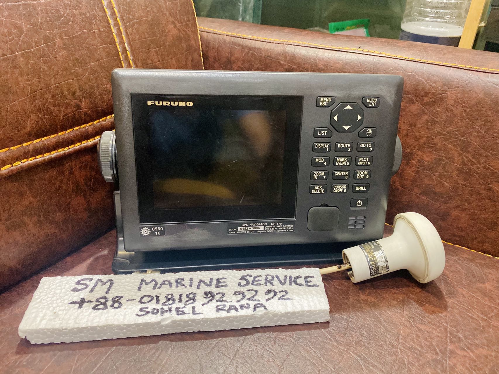
Actual Equipment Available from SM MARINE SERVICE™


What Is This Equipment?
The GP-170 is a dedicated marine navigation receiver that continuously calculates and displays vessel position using satellite navigation signals.
Unlike standard consumer GPS devices, the GP-170 is designed specifically for SOLAS and commercial maritime operations where reliability and integration are essential.
The GP-170 is commonly connected to:
- ECDIS
- AIS
- Radar
- Autopilot
- VDR
- Speed Log
- Gyro Compass
The system was developed as Furuno's advanced GNSS navigator platform and has been widely deployed on commercial vessels worldwide.
GP-170 Navigation Display & Components

Main Features
Multi-GNSS Positioning
The GP-170 supports advanced GNSS navigation for improved positioning stability and accuracy. Furuno designed the unit with enhanced signal processing and high-sensitivity GPS technology.
Route Management
- Create navigation routes
- Edit voyage plans
- Store route information
- Monitor active navigation routes
Waypoint Management
The navigator can store and manage multiple waypoints for efficient voyage planning.
Speed & Course Monitoring
Provides:
- Course Over Ground (COG)
- Speed Over Ground (SOG)
- Bearing
- Distance to destination
Bridge System Integration
Supports communication with:
- ECDIS
- AIS
- Radar
- VDR
- Autopilot
Reliable Commercial Operation
Designed specifically for continuous marine service.
Typical Shipboard Navigation Installation


Main Components
A typical FURUNO GP-170 installation includes:
Display Unit
Main operator interface for navigation monitoring.
GNSS Antenna
Receives satellite positioning signals.
Power Supply
Provides stable power for continuous operation.
Communication Interfaces
Supports NMEA communication with bridge systems.
Internal Navigation Processor
Processes satellite information and calculates navigation data.
Navigation Information Provided
The GP-170 continuously displays:
Position
- Latitude
- Longitude
Course Information
- Course Over Ground (COG)
- Bearing
Speed Information
- Speed Over Ground (SOG)
Navigation Guidance
- Distance to waypoint
- Distance to destination
- Estimated arrival information
Furuno Marine Navigation Solutions


Applications
The GP-170 is widely installed on:
Cargo Ships
Provides primary GNSS navigation information.
Tankers
Supports route monitoring and navigation planning.
Bulk Carriers
Provides continuous position tracking.
Offshore Support Vessels
Supports offshore navigation operations.
Fishing Vessels
Helps with navigation and route management.
Government & Research Vessels
Provides accurate navigation information for specialized operations.
Common Problems & Troubleshooting
No GPS Position Fix
Possible Causes
- Antenna failure
- Antenna cable damage
- Satellite signal obstruction
Solution
- Inspect antenna
- Check antenna cable
- Verify antenna power supply
Weak Signal Reception
Possible Causes
- Antenna location issue
- Connector corrosion
Solution
- Inspect antenna mounting
- Clean connectors
Incorrect Position Display
Possible Causes
- Configuration error
- Satellite reception problem
Solution
- Verify GNSS settings
- Reboot system
- Check antenna operation
No Data Output to ECDIS
Possible Causes
- NMEA communication failure
- Incorrect baud rate
Solution
- Verify interface settings
- Inspect communication cables
Route Loading Failure
Possible Causes
- Corrupted route data
- Memory issue
Solution
- Reload route
- Recreate route file
Maintenance Tips
Daily
- Verify GPS position accuracy
- Check navigation display
Monthly
- Inspect antenna condition
- Check cable connections
Quarterly
- Verify NMEA outputs
- Test connected navigation equipment
Annually
- Perform full functional inspection
- Verify system accuracy
- Conduct integration testing
Why Ships Still Use This Equipment
The FURUNO GP-170 remains popular because it provides:
- Reliable GNSS positioning
- High navigation accuracy
- Proven Furuno reliability
- Easy operation
- Long service life
- Excellent integration capability
The GP-170 continues to be displayed by Furuno alongside other flagship navigation products including AIS, ECDIS, Echo Sounders, Speed Logs, and VDR systems.
Frequently Asked Questions (FAQ)
What is the FURUNO GP-170?
The GP-170 is a professional marine GPS/GNSS navigator used for vessel positioning and route navigation.
Can it connect to ECDIS?
Yes. It is commonly integrated with ECDIS systems.
Can it provide AIS position data?
Yes. AIS systems frequently use position information from the GP-170.
Is it suitable for commercial vessels?
Yes. The GP-170 is designed for professional maritime applications.
Does it support route navigation?
Yes. The unit supports route creation, waypoint management, and voyage planning.
Can it be used offshore?
Yes. The system is suitable for both coastal and offshore operations.
Short Product Description
The FURUNO GP-170 GPS Navigator is a professional marine GNSS navigation system designed to provide accurate vessel positioning, route planning, waypoint management, and navigation data integration with ECDIS, AIS, Radar, Autopilot, and VDR systems. Its proven reliability and advanced navigation capabilities make it a trusted solution for commercial shipping and offshore operations worldwide.
SM MARINE SERVICE™
Marine Automation & Navigation Equipment Supplier
Available Condition:
• New Equipment
• Used Equipment
• Refurbished Equipment
• Reconditioned Equipment
Stock Location:
• Bangladesh
• China
Services:
• Worldwide Shipping
• Technical Support
• Spare Parts Supply
• Marine Equipment Sourcing
Contact Information
SM MARINE SERVICE™
Samir Market, DT Road, Pahartali, beside CDA Market, Chattogram, Bangladesh
Mobile / WhatsApp / Viber: +88 01818 929292
Email: info@smmarineservice.com
Website: www.smmarineservice.com
SM MARINE SERVICE™ – Your Trusted Partner for Marine Navigation, Automation, Communication & Shipboard Electronics Solutions.