FURUNO GP-150 GPS Navigator | Marine GPS Navigation System | SM MARINE SERVICE™
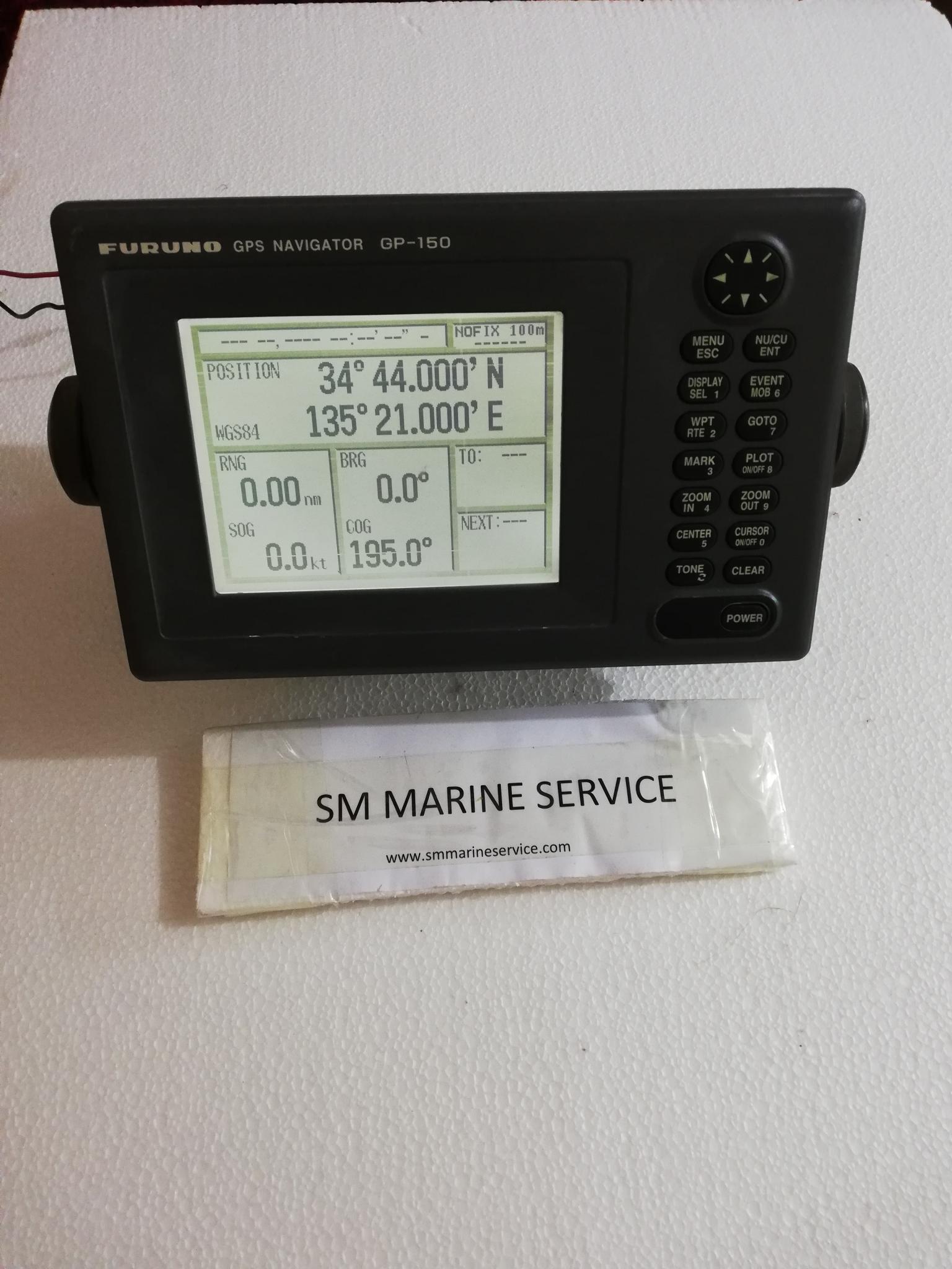
FURUNO GP-150 GPS NAVIGATOR


Manufacturer Information
Manufacturer: Furuno Electric Co., Ltd.
Country of Origin: Japan
Equipment Type: Marine GPS Navigator
Application: Vessel Positioning, Route Navigation & Navigation Data Distribution
Product Introduction
The FURUNO GP-150 GPS Navigator is a professional marine GPS navigation system designed to provide accurate vessel positioning information for commercial and offshore vessels.
Using Global Positioning System (GPS) satellite technology, the GP-150 continuously calculates vessel position, speed, course, waypoint information, and navigational data required for safe marine operations.
The GP-150 has earned an excellent reputation within the maritime industry due to its reliability, accuracy, and ease of operation.
The system is commonly installed onboard:
- Cargo Ships
- Container Vessels
- Bulk Carriers
- Oil Tankers
- Chemical Tankers
- Offshore Support Vessels
- Fishing Vessels
- Passenger Ships


What Is FURUNO GP-150?
The GP-150 is a marine GPS receiver and navigator that determines a vessel's exact position using satellite signals.
The system provides:
- Latitude & Longitude Position
- Course Over Ground (COG)
- Speed Over Ground (SOG)
- Waypoint Navigation
- Route Monitoring
- Bearing Information
- Distance-To-Go Calculations
- UTC Time Information
The GPS navigator continuously updates navigational information and distributes position data to other bridge equipment.
The system can support:
- ECDIS
- AIS
- Radar
- Autopilot
- Voyage Data Recorder (VDR)
- Navigation Monitoring Systems
Main Features
High Accuracy GPS Positioning
Provides precise vessel positioning using satellite navigation technology.
Route & Waypoint Management
Supports storage and navigation of multiple routes and waypoints.
Course and Speed Monitoring
Displays:
- Course Over Ground (COG)
- Speed Over Ground (SOG)
- Bearing Information
- Distance Information
Large LCD Display
Clear display allows navigators to monitor important navigation data.
NMEA Data Output
Supports communication with various navigation equipment onboard.
Reliable Marine Construction
Designed for continuous operation in demanding marine environments.


Main Components
1. Display Unit
Provides navigation information and system control functions.
2. GPS Antenna
Receives satellite signals for vessel positioning.
3. Processor Circuit
Processes GPS signals and calculates navigation information.
4. Communication Interface
Transfers GPS data to connected bridge equipment.
5. Power Supply Section
Ensures stable operation of the GPS system.
Applications
The FURUNO GP-150 is widely used for:
- Ocean Navigation
- Coastal Navigation
- Harbor Navigation
- Route Planning
- Waypoint Monitoring
- Position Reporting
- Navigation Data Distribution
The system remains a trusted navigation solution for vessels requiring reliable GPS information.


Importance of GPS Navigators Onboard Ships
Modern ships depend heavily on GPS systems for safe navigation.
Without accurate GPS information:
- Vessel Position Cannot Be Verified
- Route Monitoring Becomes Difficult
- AIS Position Information May Become Incorrect
- ECDIS Position Tracking May Be Affected
- Voyage Planning Efficiency Is Reduced
The GP-150 provides continuous navigation data required for safe and efficient vessel operations.
Common Problems & Troubleshooting
No GPS Fix
Possible Causes:
- Antenna Failure
- Damaged Antenna Cable
- Poor Satellite Reception
Solution:
- Inspect GPS Antenna
- Check Antenna Connections
- Verify Satellite Visibility
Position Error
Possible Causes:
- Signal Interference
- Incorrect System Settings
- Antenna Location Problem
Solution:
- Verify GPS Settings
- Inspect Antenna Installation
- Check Signal Strength
No Data Output
Possible Causes:
- Communication Port Failure
- Incorrect NMEA Configuration
- Interface Problem
Solution:
- Verify NMEA Settings
- Check Communication Wiring
- Test Data Output Ports
Display Failure
Possible Causes:
- Power Supply Fault
- Internal Circuit Failure
- Display Board Problem
Solution:
- Verify Power Input
- Check Fuse Condition
- Inspect Display Unit
Maintenance Tips
Marine engineers should regularly inspect:
- GPS Antenna Condition
- Antenna Cable Integrity
- Power Supply Voltage
- Display Operation
- Communication Ports
- Navigation Accuracy
- Alarm Messages
Proper maintenance improves:
- Position Accuracy
- System Reliability
- Navigation Safety
- Equipment Lifespan
Why Ships Still Use FURUNO GP-150
The GP-150 continues to be used by many vessels because of:
- Proven Reliability
- Accurate Position Information
- Easy Operation
- Durable Marine Design
- Long Service Life
- Excellent Furuno Reputation
Many operators continue maintaining GP-150 systems due to their dependable performance and simple operation.
Frequently Asked Questions (FAQ)
What is the purpose of the FURUNO GP-150?
The GP-150 provides accurate GPS position, speed, course, and route navigation information.
Can the GP-150 connect with AIS and ECDIS?
Yes. The system can provide GPS position data to AIS, ECDIS, radar, autopilot, and VDR systems.
Does the GP-150 require an external antenna?
Yes. A dedicated GPS antenna is required for satellite reception.
Is the GP-150 suitable for commercial vessels?
Yes. It has been widely used onboard commercial ships worldwide.
Do you supply refurbished units?
Yes. SM MARINE SERVICE™ can supply New, Used, Refurbished, and Reconditioned units depending on stock availability.
Short Product Description
The FURUNO GP-150 GPS Navigator is a professional marine positioning system designed to provide accurate GPS navigation information for commercial vessels. It supports route navigation, waypoint management, position monitoring, and navigation data distribution for safe marine operations.
SM MARINE SERVICE™
Marine Automation & Navigation Equipment Supplier
Available Condition
• New Equipment
• Used Equipment
• Refurbished Equipment
• Reconditioned Equipment
Stock Location
• Bangladesh
• China
Services
• Worldwide Shipping
• Technical Support
• Spare Parts Supply
• Marine Equipment Sourcing
Contact Information
SM MARINE SERVICE™
Samir Market, DT Road, Pahartali, beside CDA Market, Chattogram, Bangladesh
Mobile / WhatsApp / Viber: +88 01818 929292
Email: info@smmarineservice.com
Website: www.smmarineservice.com
User Manual & Technical Resources
Product Manual