
HIGHLANDER ECDIS
HIGHLANDER
Refurbished
| Item | Details |
|---|---|
| Manufacturer | Beijing Highlander Digital Technology Co., Ltd. |
| Brand | HIGHLANDER |
| Country of Origin | China |
| Product Type | Electronic Chart Display and Information System (ECDIS) |
| Application | Electronic Navigation & Voyage Planning |
| Installation Location | Ship Navigation Bridge |
| Compliance | IMO / SOLAS ECDIS Standards |
| Chart Support | ENC (Electronic Navigational Charts) |
| Interfaces | GPS, AIS, Radar, Gyro Compass, Speed Log, Autopilot, VDR |
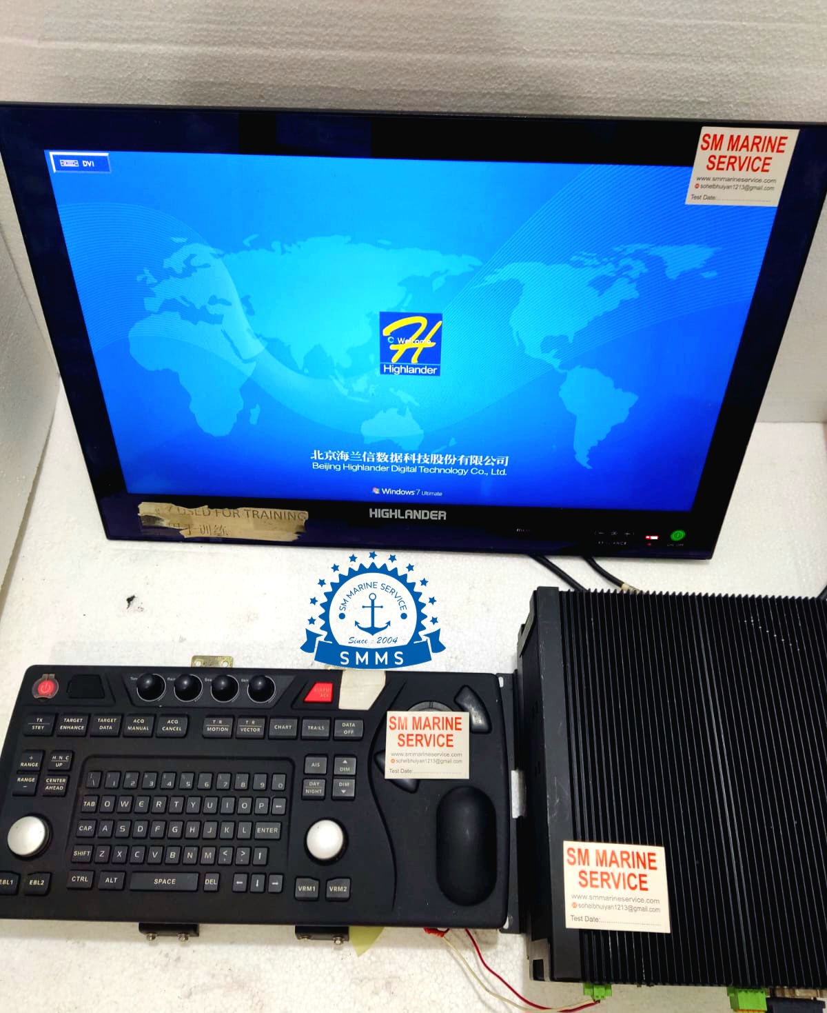
The HIGHLANDER ECDIS is a professional marine navigation workstation designed to provide navigators with a complete electronic chart-based navigation platform. The system integrates real-time vessel position data, route planning functions, radar overlays, AIS targets, navigational alarms, and voyage monitoring into a single user-friendly interface.
As paper charts continue to be replaced by digital navigation systems, ECDIS has become one of the most important navigation tools aboard modern vessels.
The HIGHLANDER ECDIS system shown in the image consists of:
This configuration enables safe and efficient voyage planning and monitoring while complying with international maritime regulations.


The HIGHLANDER ECDIS workstation provides navigators with continuous access to vessel position, electronic charts, route information, and integrated navigation sensor data.
ECDIS (Electronic Chart Display and Information System) is an IMO-approved navigation system capable of replacing traditional paper nautical charts when used with officially approved ENC charts.
The system continuously receives information from onboard navigation sensors including:
By combining all these inputs, ECDIS provides navigators with real-time situational awareness.


Displays official digital nautical charts approved by hydrographic authorities.
Allows navigators to create complete voyage plans including:
Monitors vessel movement against the planned route and generates alarms when deviations occur.
Displays nearby vessel traffic directly on the electronic chart.
Combines radar echoes with chart information for improved navigation safety.
Provides alarms for:
Interfaces with:
Stores voyage plans and navigational records for future reference.


Industrial computer responsible for chart rendering and sensor integration.
Provides chart visualization and navigation information.
Specialized keyboard for navigation operations.
Used for rapid chart manipulation and waypoint management.
Communication modules connecting external sensors.


The HIGHLANDER ECDIS is widely used aboard:
Supports long-distance route planning and voyage monitoring.
Provides enhanced navigational safety in restricted waters.
Improves voyage efficiency and route management.
Supports safe navigation in congested traffic areas.
Provides accurate route monitoring during offshore operations.
Used for tactical navigation and mission planning.
Proper maintenance ensures reliable ECDIS performance.
ECDIS remains a critical navigation system because it provides:
Integrates multiple navigation systems into a single display.
Meets SOLAS and IMO navigation requirements.
Reduces navigation risks through route analysis.
Improves route optimization and operational efficiency.
Eliminates dependence on large paper chart inventories.
Combines AIS and radar information with chart data.
To provide electronic chart navigation, route planning, route monitoring, and integrated bridge navigation functions.
Yes, when used with approved ENC charts and operated according to IMO regulations.
Yes. AIS targets can be displayed directly on electronic charts.
Yes. Radar overlay functionality is available when properly interfaced.
Typically:
Additional integration with AIS and Radar improves functionality.
The HIGHLANDER ECDIS is a professional Electronic Chart Display and Information System designed for modern commercial vessels. Featuring ENC chart support, route planning, AIS integration, radar overlays, navigational alarms, and advanced sensor connectivity, it provides navigators with a complete and reliable electronic navigation solution.
• New Equipment • Used Equipment • Refurbished Equipment • Reconditioned Equipment
• Bangladesh • China
• Worldwide Shipping • Technical Support • Spare Parts Supply • Marine Equipment Sourcing
SM MARINE SERVICE™
Samir Market, DT Road, Pahartali, beside CDA Market, Chattogram, Bangladesh
Mobile / WhatsApp / Viber: +88 01818 929292
Email: info@smmarineservice.com
Website: www.smmarineservice.com
0
BDT 0
BDT 0
BDT 0
BDT 0
Marine Equipment Supplier